काला पानी की सजा भुगत रहे कई गांव

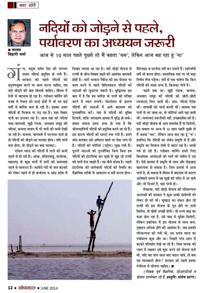
नदी है, पानी है। पानी से घिरे खेत-खलिहान। किंतु सदा नीरा नहीं, है जहरीला। 13 बरस से अभिशप्त इलाका। आम जिंदगी, उर्वर धरती, हरियाली पर काली साया, मनुषमारा का। ‘मनुषमारा’ एक नदी है, जिसे लोग कहते रहे हैं जीवनदायिनी। ये ही आज छिन रही हैं लोगों की खुशियां, खेतों की उर्वरता, फसलों की हरियाली। देने को दे रही सिर्फ गंभीर बीमारीजनित काला पानी, जहरीला जल। ताउम्र के लिए बच्sitamarhi 1 sitamarhi 2
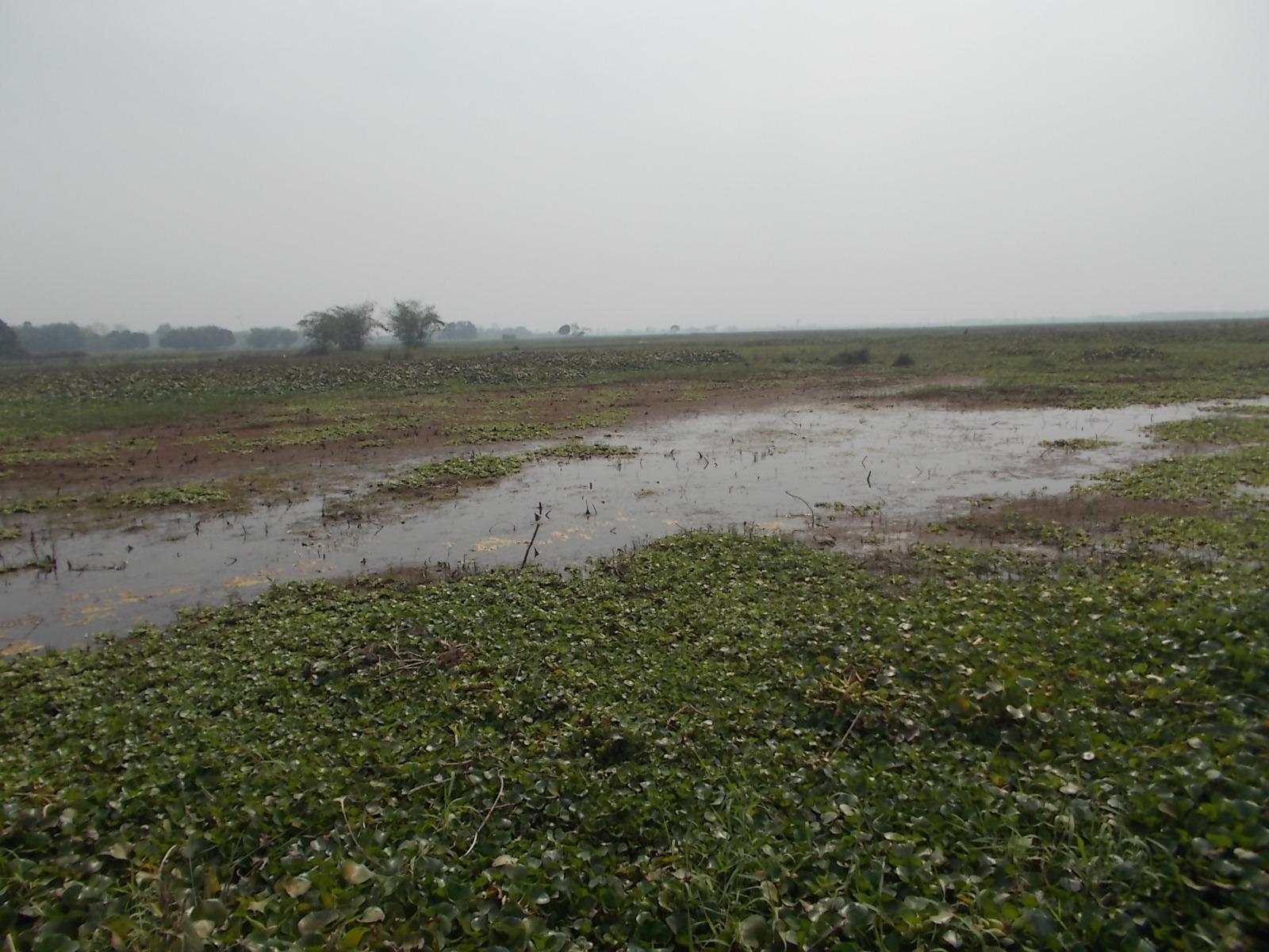
चे-बूढ़े हो रहे विकलांग, इलाका उजाड़। यही तो कहानी है रून्नीसैदपुर व बेलसंड के कई गांवों की।

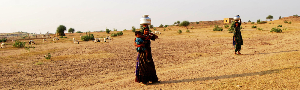
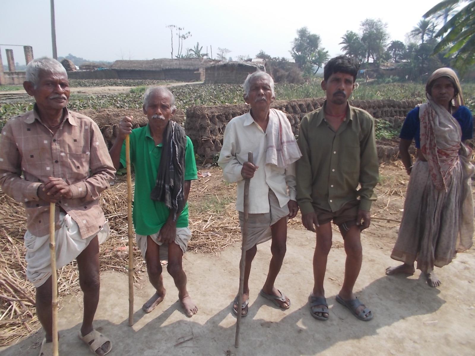
सीतामढ़ी के रून्नीसैदपुर व बेलसंड के आधा दर्जन गांवों के लिए मानो ‘मनुषमारा’ नदी अभिशाप बन गयी है। उत्तर बिहार के इस सुदूर इलाके के लोग 15 साल से काला पानी की सजा भुगत रहे हैं। खड़का पंचायत के भादा टोला गांव समेत हरिदोपट्टी, अथरी, रैन विशुनी, बगाही रामनगर पंचायतों की स्थिति बनी भयावह है। हजारों एकड़ जमीन पर काला व जहरीला पानी पसरा हुआ है। इसके चलते लोगों की खेती गयी। आजीविका का साधन छीन गया है और मुफ्त में मिल रहीं गंभीर बीमारियां। पशु-पक्षी, कीट-पतंग मर रहे हैं। जलनिकासी के लिए प्रखंड व जिला मुख्यालयों पर ग्रामीणों ने आंदोलन चलाया, लेकिन समस्या का समाधान नहीं हुआ। अधिकारी बेफ्रिक हैं, और लोग परेशान। काला पानी का असर खेतों से लेकर घरों तक हो रहा है। सबसे अधिक प्रभावित भादा टोला है, जो रसायन घुले पानी से घिरा है। इस गांव के लगभग दो दर्जन लोग विकलांग हो चुके हैं। लालबाबू राम, रामसकल राम, सुखदेव राम, कुलदीप राम व राजदेव मंडल पुरी तरह निःशक्त हो गये हैं। चलने-फिरने में असमर्थ हैं। सगरी देवी, सुमित्रा देवी, सगरी देवी, कुसमी देवी समेत दो दर्जन लोग विकलांगता के शिकार हो चुके हैं। भादाडीह टोला के ही चार लोग हसनी देवी, बलम राम, सिंकिंद्र राम व विनय राम कुष्ठ रोग से ग्रसित हैं। बलम राम बताते हैं कि हम अभिशाप ढो रहे हैं। हमें सिर्फ आश्वासन मिला है। कोई मदद करने नहीं आया है। ‘जल ही जीवन है, लेकिन इनके लिए पानी मौत बन चुकी है’ जुमला बन गया है।
इस इलाके का करीब 20,000 एकड़ भूभाग दूषित पानी में डूबा है। स्थिति इतनी भयावह हो गयी है कि यहां के लोग अपनी माटी, अपना गांव छोड़कर पलायन करने को मजबूर हैं। पिछले दिनों तिरहुत प्रक्षेत्र के आयुक्त अतुल कुमार ने रून्नीसैदपुर के दो गांवों भादा टोल व हरिदोपट्टी का दौराकर वहां की अभिशप्त जिंदगी को निकट से देखकर द्रवित हुए। लौटकर उन्होंने अपनी वेबसाइट पर पूरी रिपोर्ट लिखी थी। इन गांवों में अधिकारियों की टीम जाकर शिविर लगाया और बुनियादी जरूरतों को पूरी करने की पहल शुरू की, लेकिन उनके तबादले के बाद सबकुछ स्थिर हो गया। रैन विशुनी पंचायत के मुखिया प्रेमशंकर सिंह कहते हैं कि यहां के किसान मर रहे हैं। जलजमाव के कारण फसल नहीं हो रहा है। जो जमीन सूखी है, वहां जंगल उग गये हैं। बनसुगर से लेकर कई जंगली जानवरों से लोग परेशान हैं। जमीन भी नहीं बिक रही है। जमीन से कुछ नहीं मिला, फिर भी मालगुजारी देनी पड़ती है। लोग निराश हो चुके हैं। लेबर तो पलायन कर गये, लेकिन किसान कहां जाये।
यह समस्या 1997 की बाढ़ के बाद तब शुरू हुआ, जब मधकौल गांव के पास बागमती नदी का बायां तटबंध टूटने के कारण मनुषमारा नदी, जो बागमती से मिलती थी, उसका मुहाना ब्लाॅक हो गया और उसका एक किनारा बेलसंड कोठी के पास टूट गया। इसके बाद इसका पानी रून्नीसैदपुर से लेकर बेलसंड से धरहरवा गांव तक फैल गया। उधर, रीगा चीनी मिल से निकलने वाला कचरा इस जलधारा के जरिये करीब दो दर्जन गांवों तक पहुंच गया और समस्या को और भयावह बना दिया।
प्रेमशंकर सिंह बताते हैं कि बागमती पर रिंग बांध बनाने से यह समस्या उत्पन्न हुई। इसका समाधान जलनिकासी ही है। इसके लिए नहर खोदकर इस पानी को निकाला जाये, लेकिन यह संभव होता नहीं दिख रहा है। काला पानी की जलनिकासी के लिए अनवरत संघर्ष चलते रहे हैं। एक दशक पूर्व ही राज्य के जल संसाधन विभाग ने जलनिकासी के लिए एक विस्तृत योजना बनानी शुरू की, जो आज तक अमल में नहीं आयी। अभी हाल में नेशनल ग्रीन ट्रिब्यूनल (एनजीटी) ने पर्यावरण मानकों के उल्लंघन के लिए रीगा चीनी मिल को नोटिस जारी किया।

  • संतोष सारंग

Nepal’s disaster preparedness woefully inadequate

OM ASTHA RAI

KATHMANDU, Aug 21: Nepal has put in place plenty of plans, strategies and mechanisms to deal with disasters in the last five years.

But, is Nepal now well-prepared to manage disasters?

The answer is a big NO.

In the aftermath of the recent Sunkoshi landslide and other devastating floods, particularly in the plains of the midwestern region, it seems that Nepal´s disaster preparedness is almost non-existent.

Zero mitigation

Government officials often dub 2009 as a landmark year in the field of disaster risk management. On October 11 that year, the government approved a national strategy for disaster risk management, outlining top five priority areas.

In the years since 2009, several mechanisms, as envisioned by the national strategy, have been formed to manage disasters.

Water trapped by the August 2 landslide in the Sunkoshi River flows from two outlets dug in Mankha VDC of Sindhupalchowk district on Thursday. The water level in the trapped river had dropped by a meter and a half by Thursday. Nepal Army, which is involved in draining out the water, said it aims to reduce the water level by 15-20 meters. (Dhurva Dangal/Republica)

First of all, a consortium for disaster risk reduction was formed. The consortium, led by the home secretary, consists of development partners supporting Nepal´s disaster preparedness programs; and provides required financial and technical assistance.

Also, disaster response networks and search and rescue strategies have been prepared. The Ministry of Federal Affairs and Local Development (MoFALD) has also formed disaster management committees in many districts and villages.

So, despite all this preparedness, why did the recent floods cause so much damage in the mid-western region?

According to the National Emergency Operation Center (NEOC) of the Ministry of Home Affairs (MoHA), floods and landslides have killed 123 people, injured 67 people and left 126 people missing in several parts of the country since August 14.

In the same floods and landslides, 9,954 houses were completely damaged, 10,361 houses partially damaged, and 11,205 houses were inundated, and 20,245 families were displaced. Although the recent floods and landslides have hit as many as 25 districts, Surkhet, Dang and Bardiya are the worst affected ones.

Why did Nepal´s disaster management plans, programs, trategies and mechanisms fail to reduce the damages caused by the recent floods and landslides?

“Perhaps, our disaster preparedness is far from adequate,” says Ramesh Shrestha, an early warning system officer at Mercy Corps Nepal, an NGO working in disaster management sector.

Shrestha believes that there is no gap in disaster management policies and strategies but their implementation is far from satisfactory. “This is why disasters continue to cause so much destruction every year,” says Shrestha.

Ram Chandra Neupane, chairman of ECO-Nepal, another NGO working in disaster management sector, says, “In our plans, programs and strategies, we have focused on how to respond to disasters. But, we have failed to focus on how to mitigate risks of disasters.”

Neupane says mitigation is as important as responsiveness or even more so. “Unless mitigation is prioritized, response will always be insufficient,” says Neupane.

Constructing embankments along rivers is one of the most important aspects of mitigating the risk of floods. But, even flood-prone rivers are without embankments and flowing waywardly, killing people, damaging houses and displacing families every year.

This year, Babai River swelled up, changed its course and caused devastation in a vast area of fertile land – somewhere as far as five kilometers from the original water course. Although Babai is and was always a flood-prone river, the government has not built a strong embankment along its serpentine course so far.

Only a few months before the onset of monsoon, temporary embankments were built in some parts of Babai River, which were washed away by the flood. “Had there been a strong embankment along Babai River, damage would have been far less in Bardiya,” says Shrestha. “This is one area where our disaster management plans have failed.”

Poor response

Even in terms of responsiveness, Nepal does not look well-prepared. As part of Nepal´s flood forecasting project, nearly two dozen flood measurement stations have been set up. But, the recent floods showed these stations are too few and far between. In Babai River, the flood washed away the entire early warning system.

In the flood-ravaged villages, the displaced people have no place to sleep, no warm clothes to wear. They have been given rice. But, without kitchen utensils and fuelwood, they are unable to cook their meals. According to the NEOC, the government has distributed more than Rs 1.6 million as relief money to the flood victims. But, that seems too little.

“The recent floods and landslides showed that we are yet not prepared to deal with big disasters,” says Mahesh Gautam, president of Nepal Red Cross Society, Bardiya. “We need to go a long way in disaster preparedness sector.”


Published on 2014-08-22 02:07:15

Sunkoshi tragedy exposes failure in hazard mapping

OM ASTHA RA

KATHMANDU, Aug 7: The landslide that killed more than 150 people and blocked the Sunkoshi River last Saturday at Mankha village of Sindhupalchowk district has exposed yawning gaps in Nepal´s hazard mapping and early warning mechanisms.

Hours before the dawn of August 2, a massive landslide occurred, creating a huge debris dam that completely blocked the course of the Sunkoshi River for over 12 hours. Only after a Nepal Army (NA) team created a channel through controlled explosions, some of the blocked water started flowing downward. However, almost a week later, the dam is still there, posing flood threats to people living downstream.

As per a report released by the International Center for Integrated Mountain Development (ICIMOD), a 1.9 km long slope of land perched 1,350 meters above the river bed collapsed in Jure area of Mankha village, burying around two dozen houses. Within the first three days of the disaster, rescuers recovered 33 dead bodies from under the rubble. On the fourth day, the government declared all 123 missing people dead.

Nepal Army soldiers perched atop rocks in the Sunkoshi River as they set up ropes for possible rescue efforts in view of the continuing threat of flooding.(Phot Couresy: Nepal Army)

Immediately after the Sunkoshi landslide, the government declared downstream villages along the river a flood emergency zone and evacuated more than 100 vulnerable families from the area. As days passed, normalcy seems to be slowly returning to downstream villages. With the NA team trying to release more water through controlled explosions, a lurking crisis seems to have been averted.

However, the Sunkoshi disaster could just be a wake-up call. If serous efforts are not undertaken, immediately, more such disasters could strike Nepali villages in future, say experts.

Haphazard settlements

In Larcha, a little village located between Tatopani and Fulping Katti VDCs of Sindhupalchowk, a massive landslide had occurred in 1996, sweeping away dozens of houses. However, the landslip-affected families resettled in the same village.

The Larcha landslide is a testimony to how hundreds of thousands of families are haphazardly living in flood and landslide prone villages. They are often struck by floods and landslides but continue to live there. Worse, the government has no plans and programs to identify flood and landslide prone villages and rehabilitate people from there.

Even in Jure, the hill where the Sunkoshi landslide occurred had collapsed around 60 years ago, according to Amrit Kumar Bohara, a CPN (UML) leader who witnessed the disaster when he was just a six-year-old child. But, the locals of Jure neither relocated to safer locations nor the government ever tried to evacuate them.

Suresh Nepal, who was Vice President of the Sindhupalchowk District Development Committee (DDC) when the Larcha landslide occurred, says, “People always want to live near the road even though there is constant fear of flooding and landslides. This is why the locals in Larcha and Jure did not move elsewhere even after being struck by landslides in the past.”

It is not just the locals who choose to overlook the threats of possible disasters. Even big companies have built hydropower plants fully knowing the risks of possible floods and landslides. Along the Sunkoshi (Bhotekoshi) River, there are at least three major hydro power plants apart from many other micro hydropower projects.

“Some people know the risks but are too poor to go elsewhere,” says Arun Bhakta Shrestha, a senior climate change specialist at the ICIMOD. “But, if you look at houses built along the Sunkoshi River, it would be hard to say that all the locals are poor and therefore incapable of moving elsewhere. In fact, they take calculated risks. So do hydropower companies.”

Risks can be reduced

The Sunkoshi river basin is vulnerable to Glacial Lake Outburst Floods (GLOF) and Landside Dam Outburst Floods (LDOFs). In the last 30 years, one GLOF and two LDOF events, excluding the August 2 tragedy, have already occurred in this region.

After a GLOF event in 1981, the level of the Araniko Highway was raised and taller bridges were built in an effort to minimize damages that future GLOF and LDOF events could cause. Beside, early warning system was set up by the Bhote Koshi hydropower plant.

What was done in the wake of the 1981 GLOF needs to be scaled up, say experts. They say hazard mapping and early warning system need to be developed not only in the Sunkoshi basin but across the country. “Although we cannot control natural hazards like landslides and floods, there are many things that can be done to minimize their adverse impact on lives, livelihoods, and valuable infrastructure,” says the ICIMOD report on the Sunkoshi landslide. “More efforts to map landslide risks are needed, and much more frequent monitoring of potential landslide sites is necessary.”

Can what the ICIMOD report recommends be done? “It is not a question of whether we can,” says Dr Shrestha. “We can and we must do it. If we cannot do it across the country at one once, let us start it from the most vulnerable village. But, let us do it right now.”

Published on 2014-08-08 03:06:2

http://www.myrepublica.com/portal/index.php?action=news_details&news_id=80510

मैली गंगा में डाॅल्फिन बचाने की चुनौती

    संतोष सारंग

जलीय जीवों में डाॅल्फिन एक महत्वपूर्ण जीव है। नदियों के पारिस्थितिकी तंत्र को सुरक्षित रखने, भोजन चक्र की प्रक्रिया को बनाये रखने एवं पर्यावरण को संरक्षित रखने के लिए डाॅल्फिन को बचाना जरूरी है। गंगा एवं उसकी सहायक नदियां, नेपाल से निकलने वाली नदियां इस जलचर जीव के जीवन, प्रजनन व अठखेलियों के लिए अपना जल संसार न्यौछावर करती रही हैं। किंतु मैली होती गंगा व अन्य नदियां डाॅल्फिन के जीवन के लिए खतरा भी उत्पन्न कर रही है। इस चिंता के बीच डाॅल्फिन बचाने का प्रयास भी हो रहा है, जो स्वागतयोग्य है।
बिहार में सुल्तानगंज से लेकर बटेश्वरस्थान (कहलगांव) तक का गंगा का 60 किलोमीटर का जल क्षेत्र 1991 में ‘डाॅल्फिन अभ्यारण्य क्षेत्र’ घोषित किया गया। एशिया का एकमात्र यह डाॅल्फिन संरक्षित क्षेत्र तब से इको टूरिज्म के दृष्टिकोण से महत्वपूर्ण स्थल बन गया है। एक अनुमान के मुताबिक, 10 साल पहले इस संरक्षित क्षेत्र में करीब 100 डाॅल्फिन थे। आज इसकी संख्या बढ़कर 160-70 हो गयी है। यह सरकारी-गैरसरकारी प्रयासों का नतीजा है। यहां ब्लाइंड रिवर डाॅल्फिन प्रजाति की डाॅल्फिन पायी जाती है। इसका दूसरा नाम गंगेटिक डाॅल्फिन है। एक सर्वेक्षण के अनुसार, भारत, नेपाल, बांग्लादेश में करीब 3200 डाॅल्फिन बची है।
डाॅल्फिन के प्रति मछुआरों व आम लोगों को जागरूक करने एवं इस जलीय जीव की जिंदगी बचाने के उद्देश्य से बिहार सरकार ने 2011 में डाॅल्फिन को राष्ट्रीय जलीय जीव घोषित किया। इस साल 5 अक्टूबर पहली बार ‘डाॅल्फिन डे’ मनाया गया है। इस दिन बिहार के मुख्यमंत्री नीतीश कुमार ने डाॅल्फिन पर उत्कृष्ट काम करने के लिए डाॅ गोपाल शर्मा को प्रशस्ति पत्र देकर सम्मानित किया है।
गंगा का इतना विस्तृत क्षेत्र छोड़कर भागलपुर को इस जल क्षेत्र को संरक्षित क्षेत्र घोषित करने के पीछे कुछ इकोलाॅजिकलकारण रहे हैं। भारतीय प्राणी सर्वेक्षण, गंगा समभूमि प्रादेशिक केंद्र, पटना के प्रभारी सह वैज्ञानिक डाॅ गोपाल शर्मा को कहना है कि यहां गंगा की गहराई डाॅल्फिन के विचरण-प्रजनन के लिए अनुकूल है। पानी का वाॅल्यूम अच्छा रहता है। नदी के दोनों किनारे फिक्स रहते हैं। कटाव की समस्या नहीं है। ये सब स्थितियां डाॅल्फिन के अनुकूल है।
भागलपुर वन प्रमंडल के वन परिसर पदाधिकारी वीरेंद्र कुमार पाठक कहते हैं कि वन विभाग के पास संसाधन नहीं है। मोटरबोट हैं तो खराब पड़े हैं। नाव भाड़े पर लेना पड़ता है। इसके बावजूद साल में दो-तीन बार विभाग की टीम पेट्रोलिंग करती है। डाॅल्फिन का शिकार न हो इसके लिए डाॅल्फिन मित्र बनाया गया है। मछुआरों को सख्त हिदायत है कि वे मछलियों को पकड़ने के लिए छोटे-छोटे जाल न लगाएं, पर चोरी-छिपे वे जाल लगा देते हैं। उन्हें सिर्फ मोटी जाल लगाना है। समय-समय पर मछुआरों को जागरूक करने का कार्यक्रम चलाया जाता है, ताकि छोटी मछलियों का शिकार न किया जाये। छोटी मछलियां डाॅल्फिन का आहार है। भोजन नहीं मिलेगा, तो डाॅल्फिन फरक्का में बढ़ जायेगा। मछुआरों के आंदोलन व गंगा दस्यु के गैंगवार के कारण डाॅल्फिन संरक्षण में विभाग को परेशानी होती है। पुलिस-प्रशासन की पूरी मदद नहीं मिलती है। विभाग की माने तो हाल के वर्षों में इंडियन वाइल्डलाइफ प्रोटेक्शन एक्ट 1971 के प्रावधानों के बारे में मछुआरों को जागरूक करने व विभागीय सख्ती के कारण डाॅल्फिन की किलींग रुकी है। पटना में भी डाॅल्फिन का शिकार कम हुआ है।
हालांकि, कहलगांव स्थित एनटीपीसी थर्मल पावर से निकलने वाले रासायिनक कचरे, नाले से बहने वाले शहर के कचरे एवं शिल्क कपड़े की धुलाई में प्रयुक्त होने वाले केमिकल्स गंगा में बहाये जाते हैं, जो जलीय जीवों के लिए खतरनाक साबित होते हैं। कुछ साल पूर्व यहां बड़ी संख्या में मछलियों की मौत हो गयी थी। इस पर किसी का अंकुश नहीं है।

Cascade of Climate refugee in Jamalpur

Published on:11/11/2013

Erosion by the Jamuna River has taken a serious turn at four villages in Chinaduli union of Islampur upazila. Recently, the Jamuna river erosion threatened thousands of families at Islampur upazila in Jmalpur district. In the last month, the river erosion marked severe damage to lives and livelihoods while leaving people in danger. The badly affected unions are Kulkandi and Pathorshi. Pathorshi union has already been vanished to the river while Kulkandi is on the way to demolish.
Riverbank erosion is a perennial problem in Bangladesh. Large monsoon flow transporting extreme amounts of sediment from the Himalayan Mountains to the sea flow through the delta of Bangladesh formed by the same soils. These fine soils have no resistance to the flowing water and are easily transported and deposited. As a consequence the large rivers have quite an unpredictable behavior with the permanent risk of riverbank erosion. Riverbank erosion can exceed one kilometer per year and poses a substantial risk to floodplain dwellers. The loss of land is accompanied by a loss of infrastructure such as flood embankments, schools, hospitals, cultural and religious monuments and, of course, agricultural lands and assets.
According to BWDB It has been estimated that tens of thousands of people are displaced annually by river erosion in Bangladesh, possibly up to 100,000. From the 1970s to early the 1990s, the extent of mean annual erosion was about 3,300 hectares along both banks of the Jamuna River. During the last decade erosion along the river seems to have diminished slightly ranging from 1,000 to 2,500 hectare per year.see details

Nepal’s shifting rains and changing crops

By Saleem Shaikh
October 17, 2013
Science and Development News Network International
www.scidev.net

A short video story on how shifting rains are leading to changing crop patterns.

Watch the climate video story on this weblink: http://www.scidev.net/south-asia/climate-change/multimedia/nepal-s-shifting-rains-and-changing-crops-1.html 

A Nepalese mountain farmer, in the scenic panityanki mountain village, packs cauliflower to send them to vegetable market in Kahtmandu, Nepal’s capital. SciDev.net/Saleem Shaikh

[KATHMANDU] With weather becoming more erratic every year as a result of climate change, Nepali farmers are progressively shifting their approach, turning vast areas of rice paddies into small-scale vegetablefarming. Vegetables are more resilient as they can be hand watered in case of drought. Farmers say that with rains that used to come in April now shifting as late as mid-June, vegetables that can be sown at the time the rains finally fall are now a better investment.

But large parts of their fields now remain uncultivated due to lack of water.

The situation raises concern among experts, who warn that a shift from rice to vegetable cultivation may harm food security. They also say that without adequate support from the government farmers’ livelihood could be at risk. According to researchers, there is now a need for insurance schemes, public subsidies and improved early-warning systems to forecast extreme weather.

Website: http://www.scidev.net/south-asia/climate-change/multimedia/nepal-s-shifting-rains-and-changing-crops-1.html 

Pakistan’s mountain farmers struggle with erratic weather

By Saleem Shaikh
Thu, 31 Oct 2013
Thomson Reuters Foundation

Short climate video story
Pakistan’s mountain farmers struggle with erratic weather

http://www.trust.org/item/20131031161044-3546f/


Farmer Bibi Baskiya describes the sudden cloudburst that damaged her maize crop just a few days from harvest time in Danyore, a village in Gilgit district in Pakistan’s Upper Indus Basin area. TRF/Saleem Shaikh