Ladakh Invites New Scarcities

Athar Parvaiz

LADAKH, India, Sep 24 2013 (IPS) – The Ladakh of today is a different world from the one Skarma Namgiyal remembers as a child. Back then, he had taken for granted the breathtaking beauty of its landscape, the purity of the cold mountain air, and the sweet taste of water in its streams.

Today, at 47 years of age, this resident of Tukcha village in Leh district in the north of Kashmir cannot believe they are digging borewells for water, using water to flush toilets in their homes in place of the dry toilets they had been accustomed to, and having to cope with sewage flowing right up to their houses.

Climate change, booming tourism and modern practices are wreaking havoc in this high altitude cold desert in India’s Jammu and Kashmir state. The average elevation in Ladakh is 11,000 ft above sea level and temperatures swing between minus 35 degrees Celsius in winters to 35 degrees in summer. Annual rainfall in the region is less than four inches.

Earlier, water from the melting glaciers would be enough to cater to the needs of the locals, Namgiyal tells IPS. But with less snowfall and warmer summers, some of the glaciers have vanished altogether while others too are fast melting.

“Look at Khardongla,” says Namgiyal’s neighbour Tsering Kushu. “It used to be a huge glacier. It is not there anymore.”

More at: http://www.ipsnews.net/2013/09/ladakh-invites-new-scarcities/

Early warning technology protects Nepali villagers from sudden floods

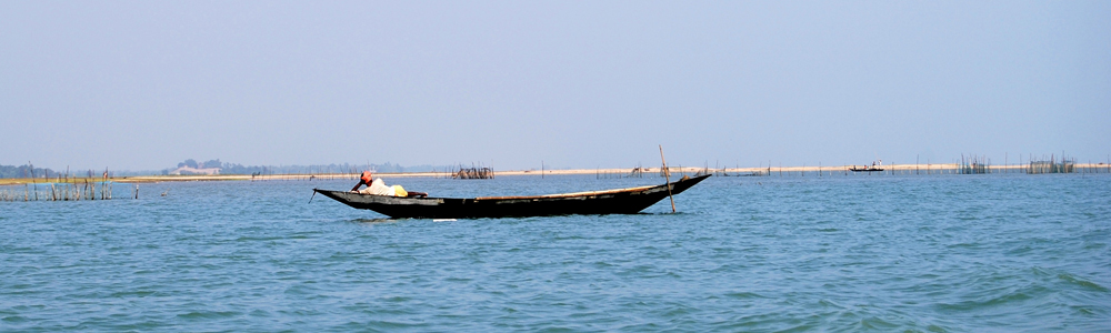
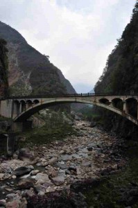
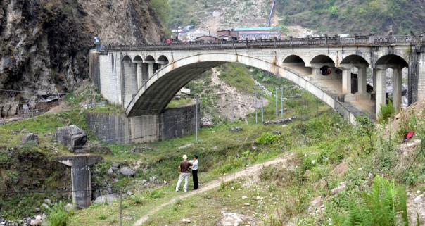
The Phulping bridge crosses the Bhote Koshi River in Jhirpu Phulpingkatti, a village near Nepal’s border with China. It replaced an old stone bridge, remnants of which can be seen to the left, which was washed away in the floods of 1981. THOMSON REUTERS FOUNDATION/Saleem Shaikh

Thomson Reuters Foundation – Wed, 22 May 2013 10:45 AM
Saleem Shaikh

JHIRPU PHULPINGKATTI, Nepal (Thomson Reuters Foundation) – For years, Deepa Newar and her neighbours lived with the fear that their livelihoods – and even their lives – might be swept away without warning.

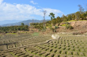
Newar and her fellow residents of Jhirpu Phulpingkatti, a village some 112 km (70 miles) northeast of Kathmandu, Nepal’s capital, live perched on the bank of the Bhote Koshi River. The river is prone to sudden, devastating floods that can swamp fields, carry away livestock and even kill those who do not manage to flee to higher ground.

The 2.5 acres (1 hectare) of land on which Newar cultivates paddy rice and maize have suffered severe flooding four times in the last 32 years, most recently in 2011.

Looking at the swirling grey waters of the river that flows into Nepal across the border with China’s Tibet Autonomous Region, 10 km (6 miles) upstream, the 39-year-old recalls those disasters.

“(The river) left behind a trail of death and destruction whenever it has turned into a monster,” she says.

But Newar now enjoys a sense of safety for herself and her family, thanks to an early warning system for floods installed by the Bhote Koshi Power Company (BKPC) at its hydropower plant on the river.

GLACIAL LAKE THREAT

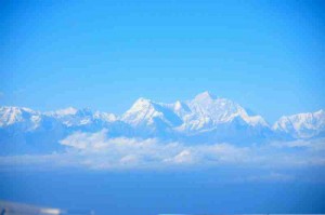
Flash floods can be caused by severe storms or the failure of levees, but the Bhote Khosi River is also susceptible to glacial lake outburst floods. These result from the catastrophic failure of a natural dam high in the mountains that contains glacial meltwater. Such failures are becoming a greater risk as warming temperatures linked to climate change lead to faster glacial melt and greater volumes of water in the lakes.

The Bhote Khosi river basin covers an area of about 3,400 square km (1,300 square miles) and has an estimated 150 glaciers. Of its 139 glacial lakes, whose area totals some 16 square km (6 square miles), 59 are highly vulnerable to outbursts, according to a study conducted by the International Centre for Integrated Mountain Development (ICIMOD), an intergovernmental body of eight countries in the Hindu Kush-Himalaya region, including Nepal and China.

In 1981, a glacial lake outburst flood in the river basin washed away several bridges, including the China-Nepal Friendship Bridge along the Araniko Highway, said Pradeep K. Mool, a glaciologist at ICIMOD in Kathmandu.

Until 2010, floods could strike the villages with no warning. Residents had virtually no time to move to higher ground and were forced to leave behind their livestock and crops, suffering financial losses as well as emotional distress.

“Before the advent of the warning system … we were at risk of being washed away,” said Newar.

Janak Raj Pant, maintenance manager at the Bhote Koshi power plant, said that the river is subject to erratic flows, particularly during the monsoon. For this reason, the power company arranged for the early warning system to be installed in 2010 to benefit the downstream communities in Sindhupalchowk district.

5 TO 8 MINUTES WARNING

The early warning system gives villagers 5-8 minutes’ notice of a flood – just enough time to save themselves.

Five flood sensors are positioned near the Nepal-China Friendship Bridge, about 6 km upstream from the power station.

If the water in the river reaches a dangerous level, the sensors activate sirens placed at four locations, including one at the power plant. The sirens warn the communities to flee to higher ground. Residents use their mobile phones to warn other villages further downstream.

According to Pant, a glacial lake outburst flood takes about five minutes to travel from the Nepal-China Friendship Bridge to the plant. He says lives can be saved if people respond to the alarm immediately.

“At present, the warning system can make the sirens blare five minutes before any flood can strike any of the 79 downstream villages of Sindhupalchowk district,” said Pant, standing beneath the red siren mounted on a side wall of the company’s building.

According to Pant, it is not currently possible to give more warning because information on flooding is not available from the Chinese side of the border.

About 40 percent of the Bhote Koshi river basin is in Nepal, with the remaining 60 percent in China.

Other residents of Jhirpu Phulpingkatti agree that the system has given them a sense of security, but they would like the lead time given by the alarm to be extended.

More sensors need to be placed further upstream within Nepal, especially at glacier snouts and where glacial lakes have formed or are forming, commented Joydeep Gupta, a New Delhi-based journalist and expert on South Asia river basins and flood warning systems.

NEED FOR CHINESE HELP

The ICIMOD study shows that Nepal has experienced at least 24 glacial lake outburst floods. Of these, 14 are believed to have occurred in Nepal itself, and 10 were the result of flood surge overspills from the Chinese side of the border. According to data from the Nepal Meteorological Department, such floods occur on average once every three years in Nepal.

The glaciers in the Hindu Kush-Himalayas are retreating, which scientists believe is the result of climate warming. As glaciers melt, the water released into lakes can build pressure on the natural dams and increase the risk of an outburst flood.

“We have already sought proposals from interested firms to expand the warning system to other vulnerable districts (near) the Bhote Koshi River,” said Pant. “It is hoped that in coming months we should be able to install alarm systems in as many districts as possible.”

“(The) Nepali government should also replicate and establish such early warning systems at all streams to (avoid) or reduce loss of lives or damage,” said Gupta.

But priority should be given to the streams emanating from the unstable glacier lakes identified by ICIMOD in its recent study, he emphasised. According to Gupta, China, as the upstream country, should collaborate with Nepal to share information about flash floods or glacial lake outburst floods hours before they reach the Nepali border, to allow maximum time for warnings to vulnerable downstream communities.

“Any viable information-sharing system by which Chinese officials can pre-inform their Nepali counterparts of any risk of flash flood or (glacial lake outburst flood) would be very helpful. A similar system between China and India already saved many lives in a flash flood in the Sutlej river area a few years ago,” he said.

Saleem Shaikh is a climate change and development reporter based in Islamabad.

Weblink: http://www.trust.org/item/20130522093446-pfy20/

The Himalayas Are Changing – for the Worse – Inter Press News Service

Last week all eyes were on the Himalayas’ highest peak – 29,000-foot Mt. Everest, whose summit is bisected by the China-Nepal border – in honor of the 60th anniversary of the first human ascent of the mountain.

But the momentous occasion presented as much cause for panic as for celebration, when images showing bare rock jutting out from under the receding ice caps called attention to the rapidly changing face of this majestic range.

Sudeep Thakuri, who led the Italian team of researchers, told IPS that the continuous and increased melting is most likely caused by rising temperatures. http://www.ipsnews.net/2013/06/the-himalayas-are-changing-for-the-worse/

Would Hillary and Norgay Recognize Mount Everest?

When Edmund Hillary and Tenzing Norgay reached the summit of Mount Everest 60 years ago Wednesday, the mountaineers gazed over a view from the top of the world that had never been seen before.

The view has changed since that historic day. Pollution and rising mountain temperatures are relentlessly shearing away at the Himalayas’ frozen façade. Photographs taken around the time of the 1953 expedition show hulking ridges of ice that have since shrunk or disappeared.

Glaciers and snow are melting throughout the sprawling mountain range, which stretches across India, Pakistan, Afghanistan, Bhutan, Nepal, and Tibetan China. The waning glaciers are leaving precarious mountainside lakes of cyan blue water in their wake.

Continue reading at Slate: http://www.slate.com/articles/health_and_science/science/2013/05/mount_everest_climb_anniversary_melting_glaciers_have_changed_the_view_from.html

Fears Grow of a Himalayan Tsunami as Glaciers Melt – TIME

While attending the 2013 PANOS South Asia Climate Change Fellowship in Nepal last month, I was quite intrigued by the possibility of a ‘Himalayan Tsunami’. Having experienced the 2004 Asian Tsunami at dangerously close quarters, I wanted to pursue this straight out of hell disaster risk. Here is the resultant story that I did for TIME –  http://world.time.com/2013/05/27/fears-grow-of-a-himalayan-tsunami-as-glaciers-melt/

Take a photo of a glacier — it’ll last longer

Farewell, great lakes of ice and frozen rivers.

Scientists used satellite images and gravity measurements to peer more closely than ever before at the torturous drip-drip-drip from the world’s glaciers. What they discovered is not really much of a surprise: Ice Age glaciers have been methodically chiseled away by the warming effects of fossil fuel burning.

Global warming and black carbon are working fast: Glaciers outside of the Greenland and Antarctic ice sheets are collectively losing an estimated 571 trillion pounds worth of ice annually, the researchers reported in a paper published Thursday in the journal Science.

Glaciers? Icesheets? Potatoes, potatoes, you say. Here’s the difference: The world’s ice sheets cover vast swaths in Greenland and Antarctica. Meanwhile, glaciers are rivers and lakes of slow-moving ice. You can find them at high altitudes in alpine regions around the world, and you’ll find them in lower elevations (including on and around ice sheets) as you approach the poles.

Although these glaciers contain just 1 percent of land ice reserves, they contribute about as much to the rising seas as the melting ice sheets. The individual contributions of glaciers to the rising seas may be relatively small, but the cumulative impacts of their melts are substantial.

The researchers concluded that melting glaciers are causing the oceans to surge by 0.03 inches yearly, which works out to 30 percent of the total annual rise in recorded sea levels.

Year 2012 among top ten warmest years: WMO

GENEVA/ISLAMABAD: The World Meteorological Organization’s Statement on the Status of the Global Climate says that 2012 joined the ten previous years as one of the warmest — at ninth place — on record despite the cooling influence of a La Niña episode early in the year, according to a WMO report released last weekend.

The 2012 global land and ocean surface temperature during January–December 2012 is estimated to be 0.45°C (±0.11°C) above the 1961–1990 average of 14.0°C. This is the ninth warmest year since records began in 1850 and the 27th consecutive year that the global land and ocean temperatures were above the 1961–1990 average, according to the statement. The years 2001–2012 were all among the top 13 warmest years on record.

“Although the rate of warming varies from year to year due to natural variability caused by the El Niño cycle, volcanic eruptions and other phenomena, the sustained warming of the lower atmosphere is a worrisome sign,” said WMO Secretary-General Michel Jarraud. “The continued upward trend in atmospheric concentrations of greenhouse gases and the consequent increased radiative forcing of the Earth’s atmosphere confirm that the warming will continue,” he said.

“The record loss of Arctic sea ice in August-September — 18% less than the previous record low of 2007 of 4.17 million km2 — was also a disturbing sign of climate change,” said Mr Jarraud. “The year 2012 saw many other extremes as well, such as droughts and tropical cyclones. Natural climate variability has always resulted in such extremes, but the physical characteristics of extreme weather and climate events are being increasingly shaped by climate change,” he said.

“For example, because global sea levels are now about 20 cm higher than they were in 1880, storms such as Hurricane Sandy are bringing more coastal flooding than they would have otherwise,” said Mr Jarraud.

WMO’s annual statements gather the key climate events of each year. The series stands today as an internationally rec­ognized authoritative source of information about temperatures, precipitation, extreme events, tropical cyclones, and sea ice extent. The newly released statement provided in-depth analysis of regional trends as part of a WMO drive to provide more information at regional and national levels to support adaptation to climate variability and change.

The 2012 climate assessment, the most detailed to date, will inform discussion at WMO’s Executive Council meeting (15-23 May 2013).

Above-average temperatures were observed during 2012 across most of the globe’s land surface areas, most notably North America, southern Europe, western Russia, parts of northern Africa and southern South America. Nonetheless, cooler-than-average conditions were observed across Alaska, parts of northern and eastern Australia, and central Asia.

Precipitation across the globe was slightly above the 1961-1990 long-term average.  There were drier-than-average conditions across much of the central United States, northern Mexico, northeastern Brazil, central Russia, and south-central Australia. Wetter-than-average conditions were present across northern Europe, western Africa, north-central Argentina, western Alaska, and most of northern China.

Snow cover extent in North America during the 2011/2012 winter was below average, resulting in the fourth smallest winter snow cover extent on record, according to data from the Global Snow Laboratory. This was in marked contrast to the previous two winters (2009/2010 and 2010/2011), which had the largest and third largest snow cover extent, respectively, since records began in 1966.

Meanwhile, the Eurasian continent snow cover extent during the winter was above average, resulting in the fourth largest snow cover extent on record. Overall, the northern hemisphere snow cover extent was above average – 590000 km2 above the average of 45.2 million km2 – and was the fourteenth largest snow cover extent on record.

Greenland ice sheet: In early July, Greenland’s surface ice cover melted dramatically, with an estimated 97 per cent of the ice sheet surface having thawed in mid-July. This was the largest melt extent since satellite records began 34 years ago. During the summer it is typical to observe nearly half of the surface of Greenland’s ice sheet melt naturally, particularly across the lower elevations. However, in 2012 a high-pressure system brought warmer-than-average conditions to Greenland, which are associated with the rapid melting.

Arctic sea ice extent reached its record lowest level in its annual cycle on 16 September at 3.41 million km2. This value broke the previous record low set on 18 September 2007 by 18 per cent. It was 49 per cent or nearly 3.3 million km2 below the 1979–2000 average minimum. The difference between the maximum Arctic sea-ice extent on 20 March and the lowest minimum extent on 16 September was 11.83 million km2 – the largest seasonal sea-ice extent loss in the 34-year satellite record.

Antarctic sea-ice extent in March was the fourth largest on record at 5.0 million km2 or 16.0 per cent above the 1979–2000 average. During its growth season, the Antarctic sea-ice extent reached its maximum extent since records began in 1979 on 26 September, at 19.4 million km2. This value surpassed the previous maximum sea-ice extent record of 19.36 million km2 set on 21 September 2006.

Extreme Events: Hurricane Sandy killed close to 100 people and caused major destruction in the Caribbean and tens of billions of US dollars in damage and around 130 deaths in the eastern United States of America. Typhoon Bopha, the deadliest tropical cyclone of the year, hit the Philippines – twice – in December. During the year, the United States and south-eastern Europe experienced extreme drought conditions, while West Africa was severely hit by extreme flooding. The populations of Europe, northern Africa and Asia were acutely affected by extreme cold and snow conditions. Severe flooding occurred in Pakistan or a third consecutive year.

Climate change is aggravating naturally occurring climate variability and has become a source of uncertainty for climate-sensitive economic sectors like agriculture and energy.

“It is vital that we continue to invest in the observations and research that will improve our knowledge about climate variability and climate change,” said Mr Jarraud.

“We need to understand how much of the extra heat captured by greenhouse gases is being stored in the oceans and the consequences this brings in terms of ocean acidification and other impacts. We need to know more about the temporary cooling effects of pollution and other aerosols emitted into the atmosphere. We also need a better understanding of the changing behaviour of extreme weather and climate events as a consequence of global warming, as well as the need to assist countries in the most affected areas to better manage climate-related risks with improved climate early warning and climate watch systems,” said Mr Jarraud.

The Global Framework for Climate Services (GFCS), adopted by the Extraordinary World Meteorological Congress in 2012, now provides the necessary global platform to inform decision-making for climate adaptation through enhanced climate information.

The story published first in Lahore Times on May 6, 2013

Weblink: http://www.lhrtimes.com/2013/05/06/year-2012-among-top-ten-warmest-years-wmo/