Climate-resilient traditional rice poised for comeback in Sri Lanka

New research by the Colombo based economic think-tank, the Institute of Policy Studies says that traditional rice varieties that went out favor in the last 60 years with the advent of hybrids, are much more reseilient than their successors. My story for the Thomson Reuters Foundation http://www.trust.org/item/20131010112839-bhdna/?source=hptop

Water volume of Imja lake doubles in three years


OM ASTHA RAI

KATHMANDU, Oct 9: In yet another sign that exposes vulnerability of Imja Tsho, one of Nepal´s highly dangerous glacial lakes, a new study has revealed that the lake´s water volume has nearly doubled over the last three years.

The new study, conducted by the High Mountains Adaptation Partnership (HiMAP), coordinated by the University of Texas and The Mountains Institute (TMI) with support from the USAID, reveals that Imja Tsho now contains over 60 million cubic meter water — almost double the lake´s previously-stated water volume.

In 2009, a study by the International Center for Integrated Mountain Development (ICIMOD) had stated that Imja Tsho, which glaciologists say was formed just half a century ago, contained about 35 million cubic meter water.

Contrary to what the ICIMOD report-2009 stated, the HiMAP study, conducted in September last year, says that the volume of water in Imja Tsho has increased alarmingly by 2012. The finding of the study was revealed for the first time at the inception workshop of Community Based Flood and Glacial Lake Outburst Risk Reduction Project (CFGORRP), an initiative taken to deal with the impact of climate change in the Khumbu region, on Wednesday in Kathmandu.

“Our study only reasserts the fact that Imja Lake is getting more vulnerable,” said Marcelo Somos-Valenzuela, a PhD candidate at the University of Texas, who was involved in mathematical calculation for finding out the lake´s water volume. “The increase of water volume in Imja Lake can be related to the rise in temperature in high mountain ecosystems.”

National Project Manager of the CFGORRF Top Bahadur Khatri says it is too early to conclude whether the finding of the HiMAP study is absolutely correct. “Other findings should validate what the HiMAP study states,” said Khatri. “But, we have no doubt that the lake´s size and water volume are both increasing constantly.”

According to the HiMAP study, the calculated volume of water that could get discharged from Imja Lake in case of a Glacial Lake Outburst Flood (GLOF) has also increased to 34 million cubic meters. Earlier, the GLOF water was calculated to be just around 20 million cubic meters.

Assessing the risk of potential GLOF events in the Khumbu region, government authorities are now accelerating efforts to lower Imja Lake´s water level by at least three meters under the CFGORRF. After Tsho Rolpa, this is the first time that a glacial lake´s water level is likely to be lowered in Nepal. Earlier in 2000, Tsho Rolpa´s water level was lowered by three meters.

Asked whether lowering of Imja Lake´s water level by three meters, especially in view of the HiMAP study´s new finding, is sufficient to avert GLOF events in the Khumbu region, glaciologist Dr Rijan Bhakta Kayastha said, “Reduction of Imja Lake´s water level by three meters is good enough for now.”

According to Dr Shrestha, an associate professor at the Kathmandu University (KU), the height of Imja Lake´s end moraine is just 30 meters, nearly 100 meter lesser than that of Tsho Rolpa. “Thanks to its low end moraine, lowering of water level by three meters is adequate for now despite the increase in the water level,” he explained.

More than 30,000 people could be affected if Imja Lake, located at an altitude of 5,000 meters just above Namche bazaar in Solukhumbu district, bursts, according to experts. The lake, surface area of which was just 0.03 square kilometers in 1960, has already developed into a 1.01 square kilometer lake.

As part of the CFGORRF, funded by the Least Developed Countries (LDC) fund of the Global Environment Facility (GEF), early-warning system will also be developed in the Khumbu region. “We will follow best practices of Tsho Rolpa while lowering Imja Lake and developing early warning system in the Khumbu region,” said Khatri.

Published on 2013-10-10 00:35:37

वाल्मीकि व्याघ्र परियोजना के जंगल में दोगुने हुए बाघ

—————————————————————–    संतोष सारंग


दुनियाभर में बाघों की घटती संख्या को लेकर पर्यावरणप्रेमी चिंतित हैं.  इस बीच बिहार से एक अच्छी खबर है. देश का 18 वां व बिहार का दूसरा टाइगर रिजर्व “वाल्मीकि व्याघ्र परियोजना के सघन जंगल में गत चार साल में बाघों की संख्या दोगुनी से भी अधिक हो गयी है. चार साल के अंतराल के बाद कैमरा ट्रैप के जरिये हुई गणना में इस वन आश्रण़ी में कुल 23 बाघों के होने का प्रमाण मिला है, जिनमें 17 प्रौढ़ बाघ हैं. शेष शावक हैं. वन अधिकारी कहते हैं कि वन विभाग के सार्थक प्रयासों का एवं बाघों की सुरक्षा व संरक्षण पर हुए खर्च का यह बेहतरीन परिणाम है. वन निदेशक संतोष तिवारी बताते हैं कि वाल्मीकि व्याघ्र परियोजना के वन क्षेत्र में बाघों को बचाने, उसके संरक्षण के जो प्रयास किये गए, वे सफल हुए हैं. कैमरा ट्रैप में कैद तसवीरों की जांच एक्सपर्ट ने की है. हम इस खबर से उत्साहित हैं. हालांकि, इस वन आश्रणी से गैंडा, स्लौथ, बीयर, पायथन लुप्त हो रहे हैं.

जंगलों में मनुष्य की बढ़ती दखलंदाजी, विकास की होड़ में सिकुड़ते जंगल एवं शिकारियों की करतूतों की वजह से देश के अभ्यारण में बाघों की संख्या कम होती जा रही है. एक अनुमान के मुताबिक बीसवीं सदी के शुरू में देश में 40 हजार से ज्यादा बाघ थे. शुरू के सात दशकों में ही जंगलों के सिमटते जाने व शिकार के कारण 1972  में बाघों की संख्या घटकर 1872 रह गयी. राष्ट्रीय बाघ संरक्षण प्राधिकार की 28 मार्च 2011 में जारी रिपोर्ट के अनुसार, बाघों की संख्या कम से कम 1571 एवं अधिकतम 1875 है. विश्व के आंकड़ों पर गौर करें तो और दुःख होगा. आज से सौ वर्ष पहले विश्वभर में एक लाख से अधिक बाघ थे. अब यह संख्या सिर्फ 3200 रह गयी है.

बाघों के संरक्षण के उद्देश्य से भारत सरकार ने 1973 में नौ टाइगर रिजर्व क्षेत्र में ‘बाघ बचाओ योजना’ शुरू की. हालांकि, अपेक्षित परिणाम नहीं आया है, लेकिन वाल्मीकि व्याघ्र परियोजना से आयी खबर हमारे सामने उम्मीद की किरण जरूर जगाती है.

संतोष सारंग

Pakistan’s mountain farmers ‘helpless’ in face of erratic weather

By Saleem Shaikh 
Thu, 3 Oct 2013 01:03 PM
AlertNet Climate, Thomson Reuters Foundation

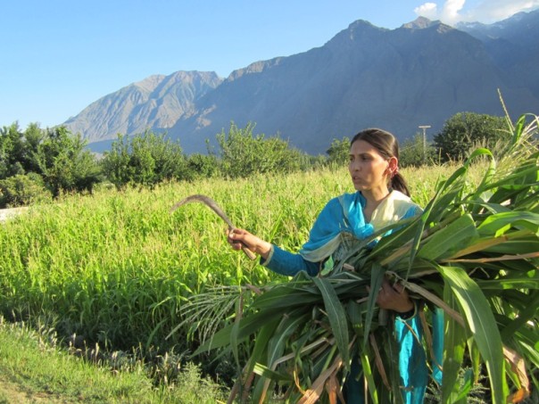
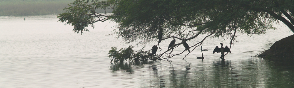
Farmer Bibi Baskiya describes the sudden cloudburst that damaged her maize crop just a few days from harvest time in Danyore, a village in Gilgit district in Pakistan’s Upper Indus Basin area. TRF/Saleem Shaikh

DANYORE, Pakistan (Thomson Reuters Foundation) – One night was all it took for Bibi Baskiya’s fortunes to be reversed. In June the young farmer had sown maize on half an acre of land in Danyore, a scenic mountain village in northern Pakistan’s Gilgit-Baltistan province.

On Sept. 12 it was sunny and the skies were so clear that Baskiya watered her crop from a nearby spring, certain there would be no rain. But that night, her hopes of a good harvest were destroyed.

“A sudden rainstorm and heavy winds flattened 80 percent of the standing crop,” she said. The maize is now only good to be used as fodder for her cattle, and she will not recover the cost of cultivating it.

Baskiya is one of many farmers in this remote region whose livelihoods are threatened by the effects of erratic weather and climate change. Experts say measures are desperately needed to help them adapt to unreliable rainfall, but few – if any – are available so far.

“We farmers are really helpless before the inconsistent weather,” said Baskiya. “We are thinking to abandon growing maize and wheat, and cultivate cash crops like tomato and potato instead that are short-duration and less water-intensive.”

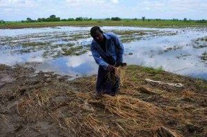
Maize is the most important summer crop after wheat in northern Pakistan’s Upper Indus Basin (UIB). The grain is harvested to eat, while the stover (dried stalks and leaves) is used to feed livestock during the winter.

“Owing to erratic weather patterns, the area under the staple crops in most of Gilgit-Baltistan province in UIB has shrunk alarmingly, and vegetables are now being grown as cash crops,” said Asmat Ali, director of the province’s agriculture department.

An estimated 70 percent of the wheat consumed locally must now be imported from Punjab province in eastern Pakistan and Sindh in the south, Ali added.

LIGHTNING STRIKES

Cash crop farmers are also suffering the consequences of extreme weather.

Ali Da’ad, 50, a vegetable farmer in Danyore, said his potato and tomato crops have been struck by lightning several times.

“There has been a significant escalation in lightning activity and thunderstorms over the last 10 years, particularly during summer months,” Da’ad said.

The lightning has triggered fires, damaging crops and endangering populated areas. At the same time, rainfall is increasingly unpredictable, causing crops to fail.

“In Gilgit district, rains are no longer even and fall patchily during the summer months,” Da’ad explained. “Sometimes it is intense and sometimes not.”

Muhammad Iqbal, chairman of Local Support Organisation Danyore (LSO-D), a nongovernmental group working for rural development, said rains are unequal even within Danyore village. “When it rains in the eastern part of the village, the west remains without it,” he said.

DELAYED SNOW MELT

Gilgit-Baltistan is home to the world’s largest frozen water reservoir, which feeds the Indus river system – a lifeline for Pakistan’s agro-based economy.

Farmers in the province depend on melting snow from April onwards to replenish streams, enabling them to sow seasonal vegetables and maize from late May. But Da’ad said prolonged winter weather is causing the snows to melt later, making it difficult to plant crops in time.

Nek Parveen of LSO-D said this year streams filled 50 days later than expected.

“Women wheat farmers in Sultanabad village (adjacent to Danyore) suffered substantial financial losses early this April, as they had to prematurely harvest after farmers sensed (the crop’s) growth had halted,” Parveen said.

According to Ghulam Rasul, a scientist at the state-owned Pakistan Meteorology Department in Islamabad, rainfall in the province has become less frequent but more intense over the past 50 years.

The decrease in winter precipitation and snowfall due to rising temperatures in the area is affecting Pakistan’s hydrological cycle and hampering the country’s agricultural growth, Rasul said.

“Investing in farmers’ climate adaptation capacity building and knowledge development can help them cope with impacts of climatic variability on their crops,” said LSO-D’s Iqbal.

HARD TO REACH

Iqbal sees a need for the construction of small or medium-sized reservoirs in the foothills and plains, so that water from streams can be harvested for use during the dry season and the winter, both for farming and domestic purposes.

But there has been little progress in the province so far, where development agencies are hampered by the inaccessibility of much of the terrain, political inertia, and a volatile security situation due to conflict between Shi’ite and Sunni Muslim sects.

Jamil Uddin, who manages programmes in the Gilgit region for the Aga Khan Rural Support Programme (AKRSP), said his organisation plans to introduce climate mitigation and adaptation measures for the province’s farmers.

“Our experiences show that information-sharing programmes for mountain farmers and communities about better, proven adaptation and mitigation measures can enable (them) to cope with the aftermath of rapidly occurring climatic variability,” he said.

The AKRSP hopes to bring climate-resilient crop varieties and water conservation technologies to farmers.

According to LSO-D’s Iqbal, transmitting weather forecasts via FM radio and free SMS texts on mobile phones would help farmers, who now rely on indigenous techniques that are increasingly inaccurate as weather patterns become harder to predict.

Iqbal emphasised that helping mountain farmers adapt to the impacts of climate change is vital to support the livelihoods of rural people and maintain an acceptable level of food security.

Saleem Shaikh and Sughra Tunio are climate change and development reporters based in Islamabad, Pakistan.

Weblinkhttp://www.trust.org/item/20131003130344-27fjs/?source=hptop

Climate change hits Ctg, Mongla ports hard

Wednesday, 02 October 2013

By Syful Islam

Impacts of climate change are frequently disrupting operations in the country’s two seaports causing huge financial losses, port officials have said.

Bangladesh is among the countries vulnerable to the impacts of climate change where storms, cyclones, flash floods, poor rainfall, droughts, and river bank erosion have become increasingly visible nowadays.

Officials of the Chittagong port, in a recent report said that being located at the coast of the Bay of Bengal the port is exposed to cyclones and storm surges and highly vulnerable to tidal surges.

“Most of the disastrous events the port experienced are related to climate change and there has been phenomenal increase in their frequency, severity and unpredictability in the recent times.

“The most severe impacts have been visualised in terms of sea level rise leading to submergence of port areas,” Syed Farhad Uddin Ahmed, secretary of the Chittagong Port Authority (CPA) wrote to the Shipping Ministry recently.

The Intergovernmental Panel on Climate Change (IPCC) in a report in 2007 said a one-metre rise in sea levels may swamp 17 per cent of Bangladesh’s low-lying areas and displace 20 million people by 2050. The IPCC in its Fifth Assessment Report, released on September 27, projected that by 2100 the sea-level might rise by 28-98 centimetres.

The World Bank Group in June this year said among the South Asian nations Bangladesh will be most affected by an expected 2° Celsius temperature rise in the next decades.

It said if temperature is up by 2.5 ° Celsius, the flood areas in Bangladesh could increase by as much as 29 per cent.

Mr Ahmed said occasionally the port operational works suffer badly and sustains damages and losses.

He told the FE that the canals and low-lying areas of the port area are being submerged even in high tide disrupting activities.

Citing some examples Mr Ahmed said during the cyclone Mahasen, the activities in Chittagong port were halted for 9 hours. The port operations remained suspended for over three days during the cyclone of 1991.

Port operations were also disrupted during major cyclones like Sidr and Aila which stuck Bangladesh’s coasts in 2007 and 2009.

Director of Mongla Port Authority Hawlader Zakir Hossain told the FE the port’s advantage is that it is located some 130 kilometres from the seashore.

“But natural disaster often disrupts activities of the port in one way or another. The cyclones Sidr and Aila had halted the port operations as those hit the nearest area with fierce velocity,” he said.

Sources said the CPA in 1992 had formulated cyclone guidelines to help contain the effects of such disasters and keep the port operational immediately after any major cyclone strikes. The cyclone disaster preparedness and post cyclone rehabilitation plan, initiated by the port is a useful tool for disaster management.

The SAARC (South Asian Association for Regional Cooperation) Secretariat is preparing a plan of action for disaster management which the CPA thinks will help establish a regional disaster management system to reduce risks.

Most of Bangladesh’s export-import activities take place through the country’s two seaports.

http://fe-bd.com/index.php?ref=MjBfMTBfMDJfMTNfMV8yXzE4NTUwMg==